|
|
|
||
|
Nebraska State Fair |
||||
|
|
The land west of the Missouri River was not open for settlement for several years after the lands were purchased as part of the Louisiana Purchase of 1803. In 1854, the land became available for settlement as a U.S. territory. Thirteen years later, in 1867, Nebraska was admitted to the union. By then a few communities had already been established. Nebraska has lots of wonderful communities to visit, explore, and learn about their local history and attractions. City names are followed by the zip, county, and population in purple. The distance from Omaha is in black. Mileages shown are road miles from Omaha's downtown Post Office to the community downtown U.S. Post Office. Some mileages are approximate. Addresses in blue (often in parentheses) will open a map link in another browser. The cities are listed starting at Omaha and working out, ... or List cities alphabetically. |
|
||
|
Dundee (Zip,* Douglas, Pop: part of Omaha) (4 miles) Dundee was annexed into Omaha in 1917. It was the wealthy housing district of early Omaha so understandably, it was a prime choice for annexation. Many of Omaha's early founders, builders, business people, built their life's dream home in the area. It has maintained its dignity as a respectable community and one you surely want to visit. Dundee celebrates Dundee Days around the third week of September. Some places you might want to check out in the Dundee area. The Cornerstone Mansion built by Charles and Bertha Offutt* is located at (140 N. 39th St. The Joslyn Castle built by Sarah and George Joslyn* is located at (3902 Davenport Street.
|
||||
|
South Omaha (Zip,* Douglas, Pop: part of Omaha) (5 miles) South Omaha was annexed into Omaha in 1917. In some ways, South Omaha is older than Omaha. A. D. Jones, a Council Bluffs resident was one of the first to cross the Missouri and mark off plots on the western side of the river. This was done before Nebraska even became a territory. The venture occurred with the constant threat of encounters with the natives who were starting to guard the area with an even more watchful eye, suspicious of likely intentions of the white settlers, especially in lieu of attempts to entice them to move to Kansas. Even before the territory was opened for settlement. A. D. Jones was appointed postmaster and immediately with the help of a Mr. Whitted, constructed a claim cabin of logs on the northeast portion of the Kountze place in South Omaha. The building was completed on the 28th of May, two days before the act creating the Territory of Nebraska. The building referred to as a "shanty" had a wide shingle with lead pencil lettering in the ordinary chirography of the times hung on it that appropriately indicated the building's purpose, reading, "Postoffice by A.D. Jones." It is said that the sign attracted as much by the quaintness of style as the information it communicated. The building was the first actual dwelling-house erected in the new country, afterward the great city of Omaha.* The El Museo Latino is located in South Omaha
(4701 S. 25th St.
|
||||
|
Florence (Zip,* Douglas, Pop: part of Omaha) (7 miles) Florence is important because it was one of the earliest settlements west of the Missouri River. Especially important is the time that the Mormons stayed on an Indian reservation in the area. There is so much to tell about Florence, that it has its own page. More Data Available.
|
||||
|
Bellevue (Zip,* Sarpy, Pop: 50,137) (12 miles) Bellevue is Omaha's closest neighbor since it is hard to tell where one ends and the other begins. Bellevue is so special, it has its own page on our website.
|
|
|||
|
Papillion (Zip,* Sarpy, Pop: 13,759) (15 miles) To the west of Bellevue is Papillion, also reachable by going south on 84th street in Omaha. To get there from Omaha, you pass right through LaVista and Ralston (off to the side). Papillion is the county seat for Sarpy County. The name of the city is not pronounced like the French word for butterfly as you may be familiar with from the 1970s movie. Our neighbor's name is pronounced Peh (as in ugh) - pill - yun. The Papillion water tower verifies that roots are the same with the beautiful butterfly mural on the side. I would just love to see that thing lift off and flutter around a bit, come down and suck up a lake or two, then go back to refill the tank.
|
|
|||
|
Ft. Calhoun (68023, Washington, Pop: 648) (15 miles) To the north of Omaha in Washington County is Ft. Calhoun, another important historical community. Ft. Calhoun is the area's third name. Ft. Calhoun is where Lewis and Clark first met with the chiefs of the "Indian Territory" on their way to the Pacific Northwest. They met with the Oto/Otoe/Missouri Indians. The meeting place was dubbed Council Bluff (notice no s on the end), Council Bluffs, and Camp Councile Bluff. The area around Ft. Calhoun was called Council Bluff after the expedition. The Indian Agency there was called Council Bluffs Indian Agency. The agency was moved to the Bellevue area in 1823 and it too was called Council Bluffs. Later, the name was used to refer to the surrounding area on both sides of the Missouri, and even later adopted by the citizens of Kanesville following the exodus of the Mormon community. Fort Atkinson, the first military barracks west of the Missouri was built in 1821* as a checkpoint for early settlers and fur traders. It is believed by some, and even documented,* that Ft. Atkinson occupied the same location as the initial council with local natives by Lewis and Clark. Ft. Atkinson was evacuated around 1827 or 1828 by Col. Leavenworth. Some time later the same barracks were again used by the U.S. Military. While Nebraska was still a territory, the barracks were commissioned Fort Calhoun (1858*) after John Caldwell Calhoun, who had passed away a few years earlier(1850). The name was adopted by the surrounding community as it sprang up. The Fort Atkinson State Historical Park located in Fort Calhoun (7th and Madison St. There are some historic markers around the community to check out as well. Because Ft. Calhoun is so close, there is no reason a history buff in Omaha shouldn't make it there for this alone. Once there, you will see what a wonderful community Ft. Calhoun is. The Washington County Historical Association preserves historical artifacts and history in several exhibits all around Washington County, including preservation of the town hall of the once thriving town known as Fontenelle. It is a good idea to read what they have done on their website or call them at 402-468-5740. The nearby 3,200 acre Boyer Chute National Wildlife Refuge was set aside to restore essential wildlife habitat. You can use the refuge for hiking, picnicking, bird watching, and fishing activities. 712-388-4800 .
|
||||
|
Plattsmouth (68048, Cass, Pop: 6,295) (19 miles) To the south of Bellevue is Plattsmouth (in Cass County), also a historic territory in Nebraska's history, first settled by the early fur traders in the area, due to its easy access to both the Missouri and the mouth of the Platte River, a slow meandering river that weaves itself into Nebraska's interior, all the way to Nebraska's western edge and Scottsbluff, although no one has made it that far in the last 100 years. The river was a safer method of travel through Indian territory since you could see further away before being ambushed (you had time to reach for the long rifle). The mouth of the Platte River empties into the Missouri near Plattsmouth. I have no idea how the town got its name. Since Plattsmouth is so rich in history, there are several historic places to visit such as their museum, some preserved homes and stores. Another opportunity to see how the simple life was in early Nebraska. Cass County is also alive with Theatre and the performing arts. Cass County residents don't have too far to travel to enjoy some local music or a stage play.
|
||||
|
Richfield (68054, Sarpy, Pop: just a few folks) (20 miles) To the south of Papillion is Richfield, also in Sarpy County. I mention Richfield because, well, it's important. We used to go to the Richfield Cafe there to eat a great dinner in as rural an area as you possibly can. Like, how rural? Population, I don't think anyone keeps track, however, just about anyone can count them up to see what the current total is. ... That rural. The cafe burned down in 1989, but the annual Richfield Run continued for a while but is no longer being held. The next run is on Sunday October 6th, 2002. Travel south on 84th to Capehart Road, go west and turn south on 102nd Street. It will lead you right into town. The run was put on by John Petersen, the same person that owned the Richfield Cafe. The run raised funds for the Make A Wish Foundation and the Sarpy County Fraternal Order of Police. Thanks John for all you did. |
||||
|
Springfield (68059, Sarpy, Pop: 1,426) (26 miles) To the west of Papillion, and slightly south is Springfield, also in Sarpy County. I mention Springfield because it's bigger than Richfield, a lot bigger.
|
||||
|
Blair (Zip,* Washington, Pop: 6,860) (26 miles) To the north of Ft. Calhoun, is Blair, where most contest entries end up (ever hear of J.D. Blair Company?). The community was not connected with the contest judging organization beforehand, only that the company looked for a location to process contest and sweepstakes entries and Blair was an easy choice to exclude from winning any prizes. Wouldn't it look suspicious if a local won? They don't seem to be upset and aren't interested in entering contests anyway, they know the odds are high, and don't bother. Other than the contest/sweepstakes enterprise, Blair is a farming community with easy access to the Missouri. It is quite a ride by river, but a great place to visit no matter how you get there. Blair had a great jump on other Nebraska cities along the Missouri when U.S. Highway 30 brought traffic along the first paved transcontinental highway back in 1915. The highway follows the Platte River for much of its way across the state. The Cottonwood Marina on the Missouri River is probably the most popular river stopping places for boaters. Throughout the summer, the hotspot has concerts featuring everything from local talent to big-name draws. Go there on an empty stomach, otherwise you will hate yourself later. Blair, Nebraska and Missouri Valley, Iowa claim DeSoto National Wildlife Refuge, however, Iowa gets true credit. In the fall, you can see thousands of geese at one time as they migrate south for the winter months. The refuge is open for boating, hiking, and picnicking. DeSoto National Wildlife Refuge Visitor's Center has ongoing programs of education, some with guided tours. The steamboat Bertrand excavation has produced several artifacts on display at the visitor's center. 712-642-4121
DeSoto National Wildlife Refuge (1434 316th Lane
|
||||
|
Ashland (68003, Saunders, Pop: 2,168) (29 miles) Ashland is 3 miles from Interstate 80 at exit 426. Several attractions are close by. The Willow Point Art Gallery & Wildlife Museum has changing shows complimenting the wonderful resident displays that bring the outdoors indoors. Hours: 10 A.M. to 6 P.M., Monday through Saturday, 12 P.M. to 4 P.M. Sunday, 402-944-3613 800-861-4260 The Denman and Mary Mallory Kounze Memorial Theatre
(Interstate 80 and Exit 426, Ashland The Strategic Air and Space Museum (previously known as SAC Museum) is right next to the Interstate. (Interstate 80 and Exit 426 The Lee G. Simmons Conservation Park and Wildlife Safari
(Interstate 80 and Exit 426, Ashland The Lee G. Platte River Art Show (Interst ate 80 and Exit 426, Eugene T. Mahoney State Park, Ashland
|
||||
|
Fremont (Zip,* Dodge, Pop: 24,429) (39 miles) To the west, and slightly north of Omaha, and Elkhorn is Fremont. Fremont got its start due to it being next to the Platte River. The land is pretty much the same elevation for a good distance around the Platte River there making it easy for lakes to form. Fremont has lakes, dozens of them. We call them the Fremont Lakes. Since Fremont is not too far from Omaha, the lakes are a favorite recreational spot. When you get to Fremont, you are in the heart of farmland. Fremont takes its name from General John C. Frémont (1813-1890), who as a Lieutenant explored the area between the Kansas River and the Platte River in 1842. He reported his frustration with navigating the Platte River and explained the Indian name of Nebraska, meaning Shallow River. The Secretary of War liked the sound of it, and so Nebraska became the name of the territory, and eventually the state. In 1856, Gen., Frémont became the first Republican candidate formed when the Whig party broke up and the Democrat Party split following the introduction of the Kansas-Nebraska Act of 1854. The Fremont Historic Visitor's Center (605 N. Broad St. The Dodge County Historical Society in the Louis E. May Historical Museum (1643 N. Nye Ave. The Fremont Area Art Association - Gallery 92 West (92 W. 6th St. The Fremont and Elkhorn Valley Railroad (1835 N. Somers Ave.
|
||||
|
|
Nebraska City (68410, Otoe, Pop: 7,127) (44 miles) Nebraska City was founded in 1850 by Stephen Nuskolls and incorporated in 1854, the same year as Omaha. Being on the Oregon Trail and on the edge of the Missouri River made Nebraska City an important spot to meet up, and get outfitted for the trip through the new west. Nebraska City is almost on a parallel with Lincoln. In the 1850s, Nebraska City saw its heyday compared to the rest of the state. A ferry crossed the river there supplying the city with trade from the east and allowing for easy shipments of the fur trade to back east. The river was easily accessible for shipments to Kansas City, St. Louis, Memphis, New Orleans, and then the world. Nebraska City had around 64 freight companies compared to Omaha, which had 24. With this type of business flow to the west, it is no wonder that Lincoln grew, mainly because Nebraska City was its outlet to the Missouri River and places back east. It was expected that Nebraska City would be the largest city in Nebraska; it was even a good contender to be the territorial capitol. When talk of connecting the east and west with railroad tracks, Nebraska City was a major consideration. The land next to the Platte River was already being considered since the grade change would be gradual. At the time, St. Louis was the largest city west of the Mississippi River. If a railroad was to cross the Missouri River inside the Nebraska Territory lines, it would surely connect to St. Louis to the east. Chicago was also a consideration*. A beeline from Chicago to the Platte River passed right through Omaha. Chicago had the help of Stephen Arnold Douglas, a prominent Chicago law partner of Abraham Lincoln, a congressman, and senator. His influence helped Chicago get chosen over St. Louis. As a result, Omaha grew faster than Nebraska City. John Brown's Cave is a local attraction, the hideout used by runaway slaves as part of the Underground Railroad. Nebraska City has a large number of apple orchards and in the fall celebrates with an apple festival called AppleJack The festival has a craft show, classic-car show, gold tournament, and lots of food! Info: 402-873-3000. Nebraska City is the start of Arbor Day, founded by J. Sterling Morton.
|
|||
|
Lincoln (Zip,* Lancaster, Pop: 192,322) (59 miles) There is so much to tell about Lincoln, that it has its own web page. More Data Available.
|
||||
|
Brownville (68321, Nemaha, Pop: 148 (72 miles) Brownville is located along the Missouri River south of Omaha, halfway between Nebraska City and the southeast tip of the state. Brownville is easily accessible from Interstate 29 (in Iowa), just 10 miles west on U.S. Highway 136. The town was formed in 1854 by Richard Brown. It was soon a booming town on the Missouri River. It was even expected to be the location of the new state capitol that would take over after Omaha's territorial capitol. Groundwork started, but due to the popularity of the railroad, river towns such as Brownville became less important. Lincoln, almost a beeline to the west got the honor instead. Brownville's popularity waned a bit but a few stayed and the history is still there. The Meriwether Lewis Museum is located in Brownville and worth the drive alone. They camped here on July 15th, 1804 on their way up the Missouri River. You can visit the encampment site from the Missouri River. Indian Cave State park is further south, just south of Nemaha about 32 miles away from Brownville. Brownville has a winery shop at 702 Main Street. The production facility is located where the grapes are grown just south of town near Nemaha. The farm has some amazing things to see. To store the wine, they restored/rebuilt the beautiful brick lined 1866 underground caves that were originally used in the Brownville Brewery. They didn't stop there; they also restored the insides of the 100+ year old barn that sits across Whiskey Run Creek with cedar that covers the walls as it is worked around the beams and supports of the barn. What is most significant is that the barn was moved there from 18 miles away, then placed across the creek. You might think that all of the nails would work themselves out during the 6-hour trip, except the barn was constructed without any nails at all. The 10 ton, 40 feet long by 26 feet wide by 33 feet high barn was built near the end of World War I in the old tradition. It now is a great place to see some wonderful Nebraska wines, and you can even have a party in a cave. The Whiskey Run Creek Winery is open Monday through Saturday from 10 A.M. to 5 P.M. and closed on Sundays. You can call for special hours at 402-825-4601 or visit them on the web. The Carson House at 3rd and Main is a fun visit. The house was built in 1860. One of the best times to visit the home is on Memorial Day because they have a tea at 2 P.M. You can visit the house between Memorial Day and the second week of October. Hours are open daily from June to August but starting in May you can visit on weekends between 1 and 5 P.M. You can visit outside these times by appointment by calling 402-825-6001. The tour is $3 for adults, and $2 for students. The Tourism Office a block away at 2nd and Main has a tour guide. You can also call toll-free at 877-559-6005. Brownville has two big flea-market events during the year; one near the end of spring and one for the start of fall. Late May (28th and 29th) and September (24th and 25th). Hours are 8 A.M. to 5 P.M. There are literally hundreds of dealers that show up for this event. 402-825-4131 or 877-559-6005 Also in the fall is the Old Time Autumn Celebration held on the first weekend of October. On the Saturday before Halloween, Brownville has a Spook-a-Rama event. Only the brave go to this because it is veerrrry scccaaaarrrry! 402-825-6491 On the first Saturday of December, Brownville has a Christmas Tour of Homes. This is not a free event; you need tickets but there is known way to get tickets. Brownville Village Theatre has plays during the summer months. Box Office Hours - 9 A.M. to 5 P.M. daily, beginning first Monday in June. The season opens the second Saturday in June. Call 402-825-4121 for reservations, or to contact by e-mail. You may also write: Brownville Village Theatre, P.O. Box 95, Brownville, NE 68321. Brownville Information website
|
||||
|
Seward (68434, Seward, Pop: 5,641) (77 miles) Seward is six miles north of Interstate 80 at exit 379, approximately 20 miles west of Lincoln. The Marxhausen Gallery is open 11 A.M. to 4 P.M. Monday through Friday, and 1 P.M. to 4 P.M. Saturday and Sunday.
|
||||
|
Tekamah (68061, Burt, Pop: 1,852) (79 miles) Tekamah, Nebraska is located north of Omaha, and Blair on the Missouri River, near Highway 32. Tekamah plays host to the Big Bottom Blues Festival each year unless they decide to cancel it. The Burt County Museum is a great place to learn about Tekameh and its history. The museum is located at 319 North 13th,. Hwy 75.
|
||||
|
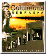
Columbus (Zip,* Platte, Pop: 19,480) (85 miles) Columbus is another one of the cities that got its start due to it being near the Platte River. The Loup River empties into the Platte at Columbus, so Columbus is actually on the Loup River. The Platte River runs under the Loup River to where they join just east of downtown. Columbus has many attractions to see. Their Columbus Days celebration is a time to get everyone out of the normal routine and relax, have some fun, enjoy the great food and festivities. The Platte County Historical Society has made a commendable effort in preserving area history in museums, restored log cabins, and early homes in Columbus and throughout the county. The Platte County Museum
(2916 16th St. Columbus honors one of its famous citizens at the Andrew Jackson Higgins National Memorial, which has a life-size replica of the Higgins boat, the boat that landed on shores with the front flipped down so soldiers could exit in a speedy fashion. Sand collected from beaches worldwide has been added to the memorial, which also pays tribute to our country's veterans. Columbus is where the wonderful Dorothy Lynch Salad Dressing became a state-wide sensation following Dorothy's restaurant success in Saint Paul*. A unique sweet and spicy salad dressing similar to French dressing that started and set the standard for salad dressings that go beyond the norm. If you are visiting Nebraska, make sure you stop by a grocery store and take some home. This way, you will always be tied to Nebraska so you can get more*. The Columbus Art Gallery
(2504 14th St. The Columbus Fairgrounds website has all the details of events and shows you will want to know about. The Columbus Chamber of Commerce website lists several additional attractions. City of Columbus
|
||||
|
Bancroft (68004, Cuming, Pop: 494) (89 miles) Bancroft is on the border of the Omaha Indian Reservation at ts southwest corner along highway 51. The John G. Neihardt State Historical Site covers Nebraska's Poet Laureate. Additionally, it has changing art exhibits. The site is open 9 A.M. to 5 P.M. Monday through Saturday, and 1:30 P.M. to 5 P.M. Sunday; 888-777-4667
|
||||
|
Decatur (68020, Burt, Pop: 641) (95 miles) Decatur, Nebraska is located midway between Omaha and South Sioux City on the Missouri River, near Highway 51. Decatur has one of the few bridges* crossing the Missouri River.
|
||||
|
South Sioux City (68776, Dakota, Pop: 9,677) (98 miles) South Sioux City is part of the community that includes Sioux City, Iowa. Cities commonly evolve at a river's edge and migrate across to the other side. When that river also is the border between states, they often have entirely different names. In this case, the portion in Nebraska is directly south of the Iowa side, hence the name. South Sioux City is on the inside of a loop of the Missouri River, actually where the Missouri heads south. There are two bridges connecting the states, one to the north, one to the east. Interstate 29 on the Iowa side makes for easy access to the north and the south. The South Dakota state line is only a few miles away - South Dakota's contribution to the community is known as North Sioux City.
|
||||
|
Tecumseh (68450, Johnson, Pop: 1,702) (98 miles) Tecumseh, Nebraska is located on Highway 136, just off Highway 50, 20 miles south of Otoe between Brownville and Beatrice in south east Nebraska. Tecumseh is built on the Nemaha River and along the BNSF Railroad. Tecumseh takes its name from a chief of the Shawnee nation. Tecumseh was named in January 1858*.
|
||||
|
Beatrice (68310, Gage, Pop: 12,357) (99 miles) Beatrice is directly south of Lincoln. Built on the Big Blue River, Beatrice was settled first by fur trappers that came up from the Kansas City area on the Kansas River and then ventured off into the Big Blue River. The first Homestead Act claim was made near Beatrice by Daniel Freedman. Beatrice was named in January 1858.* Sprangler Arlington Brugh was born near Beatrice in Filley. His family moved to Fremont for a few years but moved back to Beatrice where he got his school years education. He continued his education in Lincoln, at Doane College, and at Pomona College in southern California. When an MGM talent scout discovered Mr. Brugh, his name was changed to Robert Taylor, the actor that became known worldwide. Beatrice celebrates Homestead Days each year around the end of July or thereabouts. The celebration includes an art show, music, food booths, and historical reenactments of pioneer life. This is a fun time to enjoy Beatrice. The celebration is tied in with the Homestead National Monument of America four miles west of Beatrice. The park is a great place to visit anytime of the year to learn about early pioneer life. It is also a great place to convert museum haters. Look it up here. The monument is open 8:30 A.M. to 5 P.M. Monday through Friday, and 9 A.M. to 5 P.M. Saturday and Sunday; 402-223-3514 The Gage County Historical Museum (Second and Court St.
|
||||
|
Genoa (68640, Nance, Pop: 1,082) (105 miles) Genoa is located west of Columbus at the intersection of Highway 22 (from Columbus) and Highway 39. Genoa was settled by the Mormons on their way across Nebraska.* The Genoa Historical Museum
(402 Willard Avenue. The 1884 Genoa U.S. Indian School Museum (209 East Webster Avenue.
|
||||
|
Norfolk (Zip,* Madison, Pop: 21,485) (113 miles) Norfolk is in northeastern Nebraska, where highways 81/275 and 24/35 intersect. Norfolk was built next to the Elkhorn River, right in the apex of where the Elkhorn River is joined by one of the river's tributaries, from the north appropriately called the North Fork. Only the southern tip of the city borders the Elkhorn River. Norfolk is pronounced Nor - Fork. You can tell a foreigner is in town when they don't know how to say it. Norfolk as a town name comes from the original in England. Nebraska old-timers say the name comes from the reference to the North Fork of the Elkhorn River. The early settlers around the northern fork of the river were referred to the North Fork folks, shortened in speech to Nor-Fork-Folks, Nor-Forks, Nor-Folk, and at some point spelled out officially as Norfolk. Some say that in 1881 when the city was organized that the residents chose Norfork because it was the simplest compounding of North Fork. Supposedly, the post office changed the spelling of Norfork to Norfolk but I don't believe the post office has ever made a mistake. Regardless of how it was spelled, locals knew it referred to those folks up around the North Fork so the spelling went one way, and the pronunciation went the other. Mighty nice folks up there too, I might add.
|
||||
|
Johnny A. Carson The Norfolk Arts Center (305 N. 5th St. The Willetta Lueschen Bird Library
(515 Queens City Blvd. The Elkhorn Valley Museum and Research Center
(515 Queen City Blvd.
|
 Johnny Carson home for sale on e-bay (didn't sell) |
|||
|
Aurora (68818, Hamilton, Pop: 3,810) (125 miles) Aurora is slightly north (3 miles) of Interstate-80 mileage marker 332, slightly east of Grand Island. The Egerton Explorit Center (208 16th St. The Plainsman Museum (210 16th St.
|
||||
|
Grand Island (Zip,* Hall, Pop: 41,392) (149 miles) Grand Island is our next larger neighbor to the west. A little far to be considered a close neighbor but a major Nebraska city. Grand Island is another one of the cities that got its start due to it being on the Platte River. On the Platte River? Isn't that excessive? How could it be on the river? Grand Island is named justifiably because it started as an island. A strip of land nearly three miles in width that stretched for over 40 miles and nearly 70 miles at low water times. The northern waterway was cut off eventually to prevent crop flooding. This gives the appearance that Grand Island is north of the Platte. It expanded away from the river's edge way beyond the original island's width. The Nebraska City Cutoff, Ox Bow, and Mormon Trails passes through Grand Island. As the Mormons continued their trek west following closure of Winter Quarters near Omaha, other locations were used to camp for the winter. During the winter of 1884/85, the Mormons camped out near Grand Island. Mormon Island State Recreational Area in Grand Island is a tribute to the Mormons that camped nearby. The actual campsite is about 4 miles from the recreational area. More on Nebraska Trails. Grand Island has an active community participating in the Arts. Like Omaha has its J. Does, Grand island has its cranes. The cranes are certainly appropriate for Grand Island as it is directly in the path of the rare Whooping Crane and the much more abundant Sandhill Crane Spring Migration as they travel north in the spring. If you haven't seen several hundred to over a thousand sandhill cranes at the same time, you are in for a rare experience. In all, more than 500,000 pass through the state; the Platte River is an important stopover for the birds. Grand Island is north of I-80, Hastings is south of I-80. I-80 runs almost parallel to the Platte River in the area between the Grand Island/Hastings exit (281) and Kearney. The stretch is right in the middle of the migration path so there are several spots that will allow for excellent viewing of this majestic sight. Don't plan on stopping on I-80, that is a for-sure ticket. Check out the many side roads and especially the nature centers as they provide a much better view anyway. Crane Trust Nature & Visitor's Center is located six miles west of Grand Island. You can view the Sandhill Crane Spring Migration (late February to early April) up close from blinds. There are several miles of hiking trails along the Platte River, plus you can walk across the Platte River without getting your feet wet! Of course the river is shallow with lots of sandbars in the middle but in this case you walk on a pedestrian bridge. The center is a great place to visit all year long but the springtime is so popular you will need to get reservations. (308) 382-1820 You will want to visit the Stuhr Museum of the Prairie Pioneer in Grand island (3133 W. Highway 34 The Prairie Winds Art Center (112 W. Third St. Visit Grand Island
|
||||
|
Hastings (Zip,* Adams, Pop: 22,837) (161 miles) Hastings is south of Grand Island and south of Interstate 80. Hastings is Kool because one of its most known claims to fame is that Kool-Aid was invented there. Who didn't grow up on Kool-Aid?* Hastings was the first in the state to have an IMAX Theater. Before Omaha had an IMAX Theater, Hastings was a worthwhile trip just to see the new IMAX releases, and especially for the IMAX Film Festivals. The Hastings Museum of Natural and Cultural History (1330 N. Burlington Ave. The Sachtleben Observatory at Hastings College three miles south of Hastings (900 E. 9th St.
|
||||
|
Saint Paul (68873, Howard, Pop: 2,218) (168 miles) Saint Paul is north of Grand Island (19 miles) on Highway 281 and State Highway 92. Highway 92 heads west at Saint Paul and 281 continues north. The community was built near the Middle Loup River, with prime recreational and fishing opportunities. The Baseball Museum is a great collection of baseball memorabilia about Nebraska's contribution to baseball. The three-day Grover Cleveland Alexander Days celebration on the weekend following July 4th started several years back to honor a local baseball hero. Soon the museum was formed and now the museum honors all of Nebraska's baseball heroes. The Howard County Historical Village is located one block north of downtown Saint Paul. The village has seven historical buildings that you can tour. The Howard County Historical Society website can give you a preview of each of the buildings and also the Agricultural Hall, which is located a half block away. Their website also shows several other attractions that Saint Paul and Howard County is proud of. For example, the nationally acclaimed writer Jean Catherine Potts (born in Saint Paul), the 1908 Gruber House, the Veterans Museum, and several county historic depots with in depth coverage. The Howard County Historical Society not only preserves the history of Howard County but is also the storyteller for future generations. The famous Dorothy Lynch salad dressing got its start in Saint Paul at Dorothy's Steak House. Following the restaurant's success, Tasty Topping purchased the rights and set up shop in Columbus to manufacture the salad dressing for distribution. Saint Paul will host a rare treat this July 12-16, 2002 with a presentation by the Chautauqua group from Bismarck, North Dakota that reenacts historic events in full time-period dress. Expect to see Dolly Madison, William Clark, York, Sacagawea*, Tecumseh, and John Jacob Astor as if they were still with us today. This is the only Nebraska appearance of this group scheduled for this year. Anyone with knowledge of Chautauqua past performances will not want to miss this event no matter where you have to travel from.
|
||||
|
Gibbon (68840, Buffalo, Pop: 1,525) (174 miles) Gibbon is four miles north of Interstate-80 exit 285, closer to Kearney than Grand Island. The 1,150 acre Lillian Annette Rowe Sanctuary (44450 Elm Island Road
|
||||
|
Kearney (Zip,* Buffalo, Pop: 27,968) (186 miles) Kearney is just west of Grand Island/Hastings. Kearney is another one of the cities that got its start due to it being next to the Platte River. Fort Kearny was re-built there as part of the westward migration having been originally in Nebraska City. It would seem that the city is named after the fort, but notice that the city name has an additional letter 'e' before the 'y' at the end. If that doesn't make sense, consider this; the fort was named after Colonel Kearney, so somehow the Fort is the one that got left out. Instead, the city was named after the Colonel. You can visit the Fort Kearny National Historical Trail and see how life was in the pioneer era. Fort Kearney State Recreational Area is nearby. Together, both can take up a full day. Think about it. Kearney has a great historical play going on called the Great Platte River Road, that shows the importance of the Platte River and how it has influenced travel across Nebraska, both by the river and the land next to it. This thing is impressive. Of all the places, museums, events, celebrations, plays, or otherwise, this play is the single most important thing to take in. It will make you proud to be a Nebraskan and envious if you are visiting. The play is associated with the Archway Monument in Kearney. The monument is open 8 A.M. to 8 P.M.; Admission: adults, $8.50; senior citizens and children, $7; 877-511-ARCH. Kearney is in the Sandhill Crane Spring Migration path where a half million giant birds stop by. The best time for viewing is from late February to early April. Be especially courteous of private property owners. There are several locations made especially for viewing the birds as parks, recreation areas, or businesses between Hastings and Grand Island. The Museum of Nebraska Art is in Kearney (2401 Central Ave. The Kearney Area Children's Museum (2013 Avenue A. The Kearney Trails and Rails Museum (710 W. 11th St.
More on Kearney.
|
||||
|
Minden (68959, Kearney, Pop: 2,749) (188 miles) Minden is located along U.S. Highway 6, twelve miles south of Interstate 80 exit 279 (seven miles east of Kearney). Highway 6 passes through Omaha and was a major east-west highway across the United States in the days before the Interstate highway system was built. Highway 6 is a great tour in itself. The Harold Warp Pioneer Village (Highway 6 and 10. When you decide to travel on, Highway 6 leads you directly to McCook, then on into Denver.
|
||||
|
Niobrara (68760, Knox, Pop: 370) (190 miles) Niobrara was founded in 1856 when Dr. Benneville Yeakel Shelly and friends staked a claim on the lands. They formed a company called L'eau Qui Court Company. The company failed, so the Niobrary Township was formed. The town survived, but relocated after a great flood. Now, well established but decreasing in population. The town is next to the Niobrara River, and next to the Ponca homeland. The Niobrara State Park nearby has camping, hiking, horseback riding, fishing, and float trips on and by the river, plus Indian History, a scenic overlook, and a group lodge with swimming pool. For more information, please check out their website Niobrara State Park or call 402-857-3373. 1 mile west of Niobrara Nebraska. The Niobrara Township website has lots more information. |
||||
|
Red Cloud (68970, Webster, Pop: 1,204) (200 miles) Red Cloud is south of Hastings, built along the Republican River. Red Cloud is where Willa Cather made her home. The area has several historical and tourists spots commemorating Ms. Cather's literary contribution to society with the Willa Cather Pioneer Memorial being the major tourist site. The Webster County Historical Museum is located in Red Cloud (721 W. 4th Ave.
|
|
|||
|
Lexington (68850, Dawson, Pop: 8,544) (222 miles) Lexington is another one of the cities that got its start due to it being next to or real close to the Platte River.
|
||||
|
Bassett (68714, Rock, Pop: 606) (240 miles) Bassett is centered on east-west U.S. Highway 20 and Clark Street, a north-south street, which is also US. Highway 183 to the south of U.S. Highway 20, and Nebraska Highway 7 to the north of U.S. Highway 20. Both Nebraska Highway 7 and U.S. Highway 183 join with U.S. Highway 20 to the west of Clark Street. The intersection is the location of Bassett High School. The Rock County Airport is a short distance southwest of downtown Bassett on U.S. Highway 20/183/Nebraska Highway 7. Bassett has been the County Seat for Rock County since 1890. Bassett was started in 1878 when settlers chose the rich farmland and cattle grazing area near the Niobrara River in central northern Nebraska, just a short distance from the South Dakota border. Later on the same year, Captain Andrew N. Bassett formed a cattle ranch on Lone Pine Creek bringing Texas Longhorn cattle. The area where he herded his cattle became known as Bassett. Within a few years, the community grew as prairie schooners traveling along the Black Hills Trail west found the area suitable to farm and build a community. Mail started to be delivered to settlers along the Niobrara, so a post office was established, and a school was formed within a short time. When the railroad reached Bassett in 1881, there was no holding back any longer. A newspaper, The Bassett Herald was formed in 1884, and the village of Bassett was officially incorporated in February 1887. The Visitors Center is housed in an old creamery that has been restored for its current use. There is a Phillips 66 Gas Station that looks exactly how it looked during its heyday, and it will remain that way for some time to come because it has been restored as a historic landmark. It is nice to see a gas station preserved, probably one of very few that will ever get this nice treatment. The town has 92 acres of parks, so if a picnic is on your agenda, you will have lots of variety to choose from. If cooking your own Rock County steak is the goal, several have cooking facilities, covered picnic tables, and playground equipment to distract the young ones until the food is ready. If you just want to sink your teeth into the best Nebraska steaks, you will find there are several choices to be had. Bassett knows how to serve up good food. Being along the Niobrara, there are several state recreational areas nearby. You are not far from the Merritt Reservoir and the Calamus Reservoir, both offering many recreational opportunities in and around the water. The Rails to Trails hiking and bicycling route along the Niobrara River passes through Bassett. The Bassett Museum has helped capture some of the history of Bassett, and should not be missed. They have preserved several original buildings, each with original period pieces. One very special park, Memory Lane Park in Bassett, helps tell the Basset history through examples of early prairie life, and the cattle ranchers that settled nearby. If you would like to buy some cattle from good stock, make sure you are in Bassett on Wednesday, and at the Stockyards early. You could get some good tips at breakfast if you stay at the Bassett Lodge and The Range Cafe, unless you are more interested in getting an early start. You can do very well by making friends and chatting on Tuesday evening too. If you are earnest, you will end up with some good cattle; and if you are not, you will end up with some bull. Cattlemen are always happy to help new folks to the area as long as it does not interfere with their own purchasing or selling goals. Be honest, and you will do good, and you will make some lifelong friends; you will need it if you plan on getting into the cattle business. The Bassett Arts Council arranges many impressive cultural events throughout the year, especially in the warmer months. Many touring groups have performed on the Bassett Band Shell in the downtown park. If you plan your visit at the right weekend, you could be treated to some outstanding performances, all while making some great new friends from the community. The Arts Council even has its own gallery in downtown Bassett. Giving young people a place to develop and show their art is a great achievement for any community. Not only will you feel right at home in Bassett, you may choose to make it your home. Nice folks there.
Sandhills Ranch Expo is held in June of each year in Bassett at the fairgrounds. |
||||
|
Comstock (68828, Custer, Pop: 135) (261 miles) Comstock is located in the middle of the state, and that is pretty much from any direction. It is north of Kearney. To get there, take state Highway 40, from Kearney to US 183 north, then head east on S21C seven miles to Comstock. Why would you be going there? To see where they had the largest Country Music festival in the Midwest but due to funding canceled 2011 concerts, postponing to 2012.
|
||||
|
|
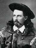
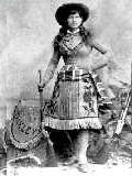
North Platte (Zip,* Lincoln, Pop: 23,307) (281 miles) North Platte is another one of the cities that got its start due to it being next to or real close to the, what else, the Platte River. What is important about North Platte and the Platte River is that the Platte River splits there and is formed by two rivers feeding the river, appropriately named the North Platte and South Platte Rivers. The joining of two rivers made this location a popular congregation point for travelers along the Platte River Road. The Oregon Trail, Overland Trail, Mormon Trail, and Pony Express all passed through this area. When the railroad came along, this was an obvious stopping point. Union Pacific has built so much in North Platte that it is the largest railroad yard. You can learn all the details on the Chamber of Commerce website and the Union Pacific website. Rivers and lakes provide our favorite camping spots and North Platte has several in the area. Directly south of North Platte (six miles) is North Platte is where Buffalo Bill decided to create his Wild West Show and the first Rodeo. You can visit Buffalo Bill's Ranch State Historical Park and Wild West Arena. The Fort Cody Trading Post and Old West Museum in North Platte has many exhibits, plus a show to enjoy. If you find yourself anywhere near the area, the show should not be missed. The North Platte Tourism website lists several attractions in the area. They are an excellent local resource.
City of North Platte
|
|||
|
McCook (69001, Red Willow, Pop: 7,994) (288 miles) McCook is located along U.S. Highway 6, which also passes through Omaha making Highway 6 a major east-west highway across the United States in the days before the Interstate highway system was built. The location of McCook was decided on before the Interstate highway system was developed; the original location chosen as a division point between the Missouri River and Denver for the railroad. The city was established when the Chicago, Burlington, and Quincy Railroad Company authorized the Lincoln Land Company to build a town near the existing site of Fairview, a frontier outpost and cattlemen's trading center along the Republican River. Being cut off from the major flow of traffic has affected the economy of McCook and in the process has created what could now be considered a wonderful getaway from the mainstream. If you are the type of person that wants to see real America, find the antiques that have been bought up in the traveled markets, and enjoy great meals, yet prefer a fairly easy access, consider traveling the old U.S. Highway 6 west to McCook. The folks there will welcome you as family, appreciate your business and patronage, and give you enough incentive to return at your very earliest opportunity. Senator George Norris resided in McCook to be near the people he represented. Upon completion of public service, he returned there to live out the rest of his life. He is honored in a nearby memorial. The Museum of the High Plains (421 Norris Ave. When you decide to travel on, Highway 6 leads you directly into Denver.
|
||||
|
Valentine (69201, Cherry, Pop: 2,826) (300 miles) Valentine, Nebraska is located at the northern edge of the state and in the middle. It too was built next to a major river, the Niobrara River. Valentine is special for a couple of reasons. It is in Cherry County, the largest county in the entire U.S. The second reason, and one dear to my heart, is the name itself. What can be greater than to receive a Valentine card from Valentine? It is possible Valentine and the surrounding countryside is breathtaking, so if you want to get a taste of true Nebraska, this is as real as it gets. The Merritt Reservoir State Recreation Area near Valentine has woods and water. Wow, what a place. 402-376-3320
|
||||
|
Ogallala (69153, Keith, Pop: 5,638) (330 miles) Ogallala is another one of the cities that got its start due to it being next to or real close to the Platte River, on the southern feeding leg, the South Platte River. Ogallala was named after the Native Americans that resided in the area. Their name was also spelled Oglala, as in the Oglala National Grasslands in Dawes County. You wouldn't want to miss the Cowboy Museum emporium (Front Street) (519 East 1st St.
|
||||
|
Big Springs (69122, Deuel, Pop: 505) (345 miles) Big Springs isn't all that big in land mass or population, but it is large in history. It the last spot before heading down steep inclines into Colorado. This was more important in the days of the wagon trains that traveled west, and needed to be let down by rope, a little bit at a time. The Ash Hollow State Park and Museum is nearby plus there is a great scenic overlook. The folks in Big Springs really cater to out-of-towners and are more than willing to accommodate your visit to the area. They do have a lot to show off in the area.
|
||||
|
Alliance (69301, Box Butte, Pop: 9,765) (397 miles) Alliance is in the butte area of western Nebraska. There are no major rivers nearby so how did this town ever get started? It is pretty there. Water is always an important necessity and the area is not totally void of water. There are several creeks in the area (Snake, Berre, Hemingford, and Box Butte). Alliance is slightly higher than the valleys to the north and the rolling hills making up the Sandhills to the east. Of the entire Sandhills, the largest number of lakes is right next to Alliance. As a result, it turns out to be the perfect place for a community to form to have access to offerings of the surrounding area. Roads lead directly north, northwest, southwest, and east, right through the middle of the Sandhills. Alliance is a wonderful door to the Sandhills and the northwestern communities of Nebraska. While near Alliance, you must check out Carhenge, Nebraska's monument of ancient (70s) cars stuck in the ground by mysterious forces (serious farm equipment). The Carnegie Arts Center
(204 W. 4th St. The Knight Museum of the High Plains Heritage (908 Yellowstone Ave.
|
||||
|
Sidney (69162, Cheyenne, Pop: 6,010) (400 miles) Sidney is in western Nebraska along Interstate 80. The name came from the military fort that was built there as part of the westward migration and railroad workers. At Fort Sidney, the southern branch of the Oregon Trail turned north to join up with the northern branch around Bridgeport, Nebraska, continuing on towards Scottsbluff. Between Sidney and Bridgeport, the Oregon Trail follows a similar path as the Sidney Deadwood Trail, which continues on north into South Dakota, where the treasures of gold were found in the Black Hills. The Ft. Sidney Post Commander's Home (1153 6th Ave. The Living Memorial Gardens is part of Legion Park in Sidney. The living plants are a memorial to veterans and Sidney's past contributors to our history. You should have no trouble locating the gardens due to the enormous flag atop a 141 foot flagpole. For more information, call 308-254-5851, or 800-421-4769. Sidney is home to the nationally known hunting, sports, and outdoor company Cabela's. This is probably the biggest store of its kind. Prepare to spend some time, even if you only stop to look at all the trophy mounts; there are (easily) over 500 to see. The store also has deals that don't appear in their catalog. If you like camping, make an effort to stop by. They have information on all the greatest places to camp, not only in Nebraska, but countrywide. City Website Cheyenne County Chamber of Commerce e-mail
|
||||
|
Chadron (69337, Dawes, Pop: 5,588 (437 miles) Chadron is in northwestern Nebraska, also set in beautiful country. Chadron was a popular fur trading post even before Nebraska became a state. A museum shows off the early tools of the trade along with some of their stories. The Chadron State Park is popular with campers and fans of other outdoor activities. South of town on state road 383 is the Chadron Creek Trading Post State Historical Marker. The Chadron Municipal Airport is on the west side of town for those that like to preview your vacation spot from the air first. Dawes County Historical Museum Box 1319 - Chadron, NE 69337 (Highway 385, 5 miles south of Chadron) - 308-432-3843, Open: June 1st to October 1st Mari Sandoz High Plains Heritage Center (at Chadron State College) 1000 Main Street - Chadron, NE 69337 (Highway 385, 5 miles south of Chadron) - 308-432-6401, Open: All year, closed College of Chadron holidays and Sundays, M-F: 8 A.M. to Noon, 1 P.M. to 4 P.M., Sat: 9 A.M. to Noon, 1 P.M. to 4 P.M. Fur Trade Museum 308-432-3843, Located on U.S. Highway 20 just 3 miles past Chadron, NE. and 26 miles east of Crawford - Open: 8 A.M.-5 P.M. Memorial Day through September Trailside Museum 308-665-2929, Open: year round. Located at Fort Robinson State Park (3 miles west of Crawford) Hudson-Meng Bison Bonebed 308-665-2929, Open: 9 A.M.-5 P.M. May 15th - September 6th Prices: Adults $4, Children $1, 6 & under Free - Located 10 miles Northwest of Crawford (4 miles north of Crawford on Highway 2 & 71, Turn west (left) onto Toadstool Road. Follow signs to Sand Creek Road. Turn left onto Sand Creek Road and drive 6 miles to the site) Agate Fossil Beds National Monument 308-668-2211, Open on non-holidays, 8 A.M.-5 P.M. (6 P.M.) Prices: Individual: $3 (good for 7 days), Vehicle: $5 (good for 7 days), or an Annual Park Pass $15 - Located 26 miles west of Chadron on Highway 20. (Take Highway 20 to Harrison; Left (South) on Highway 29 for 22 miles; Left onto River Road; Proceed East three miles to Agate Fossil Beds).
|
||||
|
Rushville (69360, Sheridan, Pop: 1,100) (450 miles) Rushville, the county seat of Sheridan County is in northwestern Nebraska, 90 miles east of the Wyoming border and 25 miles from the South Dakota state line. U.S. Highway 20 and Nebraska Highway 87 intersect one mile west of Rushville. Nebraska Highway 250 runs south of Rushville to connect with Nebraska Highway 2. Rushville is 450 miles northwest of Omaha, Nebraska; 312 miles northeast of Denver, Colorado; and 130 miles southeast of Rapid City, S.D. |
||||
|
Scottsbluff (Zip,* Scottsbluff, Pop: 13,711) (452 miles) It's different out there. It looks different. And its cool. Not really a close neighbor to Omaha but important since it is at the opposite end of the state and at the other end of the (North) Platte River portion that is inside the state of Nebraska. Rarely does anyone from Scottsbluff visit Omaha. If they have a hankering to go to a big city, they choose Denver, or Cheyenne, or something closer than Omaha. When someone from Scottsbluff does make it to Omaha, they must be here for something serious. We feel so honored that we feel guilty for not throwing a party. Nearby towns are Minatar (Pop: 801) to the east and Mitchell (Pop: 1,743) to the west. To the north of Scottsbluff is the North Platte National Wildlife Refuge. There are several lakes, among them, Lake Alice, and Lake Minatare (next to Minatare Lake State Recreational Area). Understand that the town Minatare is slightly south of Scottsbluff, the lake slightly north, both to the east. Scottsbluff is part of a larger community made up of Gering (Pop: 1,946), and Terrytown (Pop: 656), each with official borders. This community is joined by the Scottsbluff National Monument with its own borders. Collectively, the community as a whole and nearby surrounding area has a lot to offer as far as historic and tourist sites, easily as much as any other place in the state. One of the great attractions to visit is the Riverside Zoo (1600 S. Beltline Hwy Ft. Mitchell was built there as part of the westward migration. The Pony Express and Mormon Trail passed by Scottsbluff. The Scotts Bluff National Monument visitor's center, three miles west of Gering, has lots of information on early pioneer life and especially, the history of the people traveling along the Mormon Trail, and of course stories from the Pony Express times. It is worth the trip even if you had to walk there alongside a Conestoga wagon. You can visit a preserved Pony Express Station near the Oregon Trail Marker, which is near the Ft. Mitchell historical marker. The Wildlife World at the Wyo-braska Natural History Museum in Gering (950 U St. The Wildcat Hills Nature Center and Nature Center in Gering is great for hiking to get some scenic shots of the area, buffalo, elk, and other wildlife. Camping: $3 308-436-3777 The Western Trails Scenic and Historic Byway, the first in the nation, shows off just how beautiful the country is in western Nebraska. Plan on half a day to cover everything you can see, but you will probably need more time. While in the area, consider visiting Henry (Pop: 145), still in Scottsbluff County but right at the state line, where another Oregon Trail historic marker has been placed. The Horse Creek Treaty Grounds State Historical Monument is just south of Henry. These historical sites are worth the drive alone, even if there were no great scenery to enjoy. The entire area is beautiful country so make sure you have loads of film or a large digital media card for your camera. If you are a visitor, to the day you die, you will pull those photos out to gaze at and show off to folks. If traveling west on Interstate 80, you would take U.S. Highway 26 to Scottsbluff. Along the way, you will see Chimney Rock National Monument real close to the signs for Bayard. Stop and take some pictures because you only have about 40 miles left to get to Scottsbluff. Schedule your trip to arrive there in the afternoon. Along with the unexpected stops (such as at Bridgeport), you want to make sure you don't get to Chimney Rock too late. I assure you, sunset can creep up on you especially when you are driving. You absolutely need to check and see when the sun sets for the day you will be there, and then make sure you have plenty of time to get there. If you made reservations for Scottsbluff, there is no rush, so you can get some great sunset shots, get into town in time to eat, settle down, and start a full day of exploring Scottsbluff the next morning. It may take more than a day. Some people started years ago and haven't left yet. The West Nebraska Arts Center
(106 E. 18th St. Additional Info: Visit Scottsbluff
|
|
|||
|
Whitney (69367, Dawes, Pop: 30) 42:46:58 N, 103:15:20 W (453 miles) Whitney, Nebraska is located in the northwestern part of the state on the northern side of White River. It was built next to the Fremont Elkhorn Missouri Valley Railroad Line. Its history predates the coming of the railroad however. From 1883 to around 1885, a settlement formed on the south side of White River, going by the name of Dawes City. The terrain was low and had flooding problems. In 1887 when the railroad came through, people from Dawes City started a town across the river known as Earth Lodge. More and more folks moved across the river and eventually, Dawes City was abandoned altogether. Not only was the north side next to the railroad, but it also was on higher ground. More and more people of Earth Lodge didn't like the sound of it, figuring that other people might think they were living in sod houses so they decided to rename the town. The name Whitney came from Peter Whitney, an agent of the Chicago Northwestern Railroad and an officer in the Pioneer Town Site Company. |
||||
|
Crawford (69339, Dawes, Pop: 1,115) (458 miles) Crawford is in northwestern Nebraska, 21 miles southwest of Chadron, in the beautiful Pine Ridge area. Fort Robinson State Park is three miles to the west. The Black Hills of South Dakota is only 50 miles north. Besides being a popular hiking, camping, and outdoor activities location, Crawford is especially a popular spot for hunters and is known as the Big Game Capitol of Nebraska. Crawford was established in 1886 when the Fremont-Elkhorn Railroad needed a stopping spot for water. The historic Sidney-Deadwood Trail crosses through Crawford on its north-south path. Crawford is also home to the Lover's Leap Winery. The area having sloping hills and gentle breezes make it an ideal spot to grow grapes in the old world tradition. Using American cultivars and French Hybrid grapes, their International Award Winning Wines are proof that Nebraska can produce wines on a level with any other state in the nation. Local artwork decorates their tasting room where you can experience a wide variety of grape wines and even wines made from honey. You can also check out their wines in their Sidney store next to Cabelas Sporting Goods. Anyone crossing the state or visiting Crawford should stop by to add a few bottles to their collection. Some historical locations to visit are the German P.O.W. Historical Marker at Lake Crawford, and the Red Cloud Agency State Historical Marker, both southwest of town and in Fort Robinson State Park.
|
||||
Nebraska's Chamber of Commerce Links |
This list is in no way conclusive but does help to mention some of Nebraska's major communities. You can't cover every community in a single vacation or business trip. You can use the Interstate to get near but you have to get off onto Nebraska's side roads to enjoy the real beauty of what Nebraska has to offer. Only one caution, it is addicting. |
|